


Finland 2014 app for iPhone and iPad
Developer: Kari Kulmala
First release : 24 May 2011
App size: 223.79 Mb
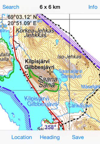
This app includes general maps of Finland (scales 1:2 000 000 and 1:1 000 000) and topographic maps at scale 1:500 000 and 1:250 000. Using the app doesnt require an internet connection. You can use pinch zoom or zoom in by double tap and zoom out by two finger tap.
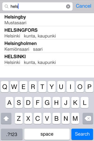
Search list includes over 13 000 place names. Under the place name there is the name of the municipality where that place is and an optional place type (in Finnish). Heading button shows where the device is heading: 0° is grid north, 90° east etc.
With Location button you can load a map centered to your location. Your coordinates are shown in blue numbers and center of the screen is shown in black numbers. Gray grid has different size depending on zoom factor. You can see the grid size in the title bar. You can save the map to Photos app and for example email it from there.
App contains data from the National Land Survey of Finland Topographic Database 09/2014: NLS General map raster 1:2 000 000 and 1:1 000 000, NLS Topographic map raster 1:500 000 and 1:250 000 and NLS map names (KNR500) 1:500 000.
National Land Survey open data licence: http://www.maanmittauslaitos.fi/en/NLS_open_data_licence_version1_20120501
See also my other map apps, e.g. "Helsinki topo" which includes topographic maps around Helsinki area (scales 1:50 000, 1:100 000 and 1:250 000).